Rio de Janeiro

Iguassu Falls
Manaus, Amazon
Salvador, Bahia
Pantanal South
Fortaleza
» Fernando Noronha
Natal
Recife
Ouro Preto
Brasilia

Iguassu Falls
Manaus, Amazon
Salvador, Bahia
Pantanal South
Fortaleza
» Fernando Noronha
Natal
Recife
Ouro Preto
Brasilia


From state prison to ecological paradise
Introduction
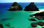
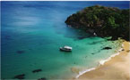
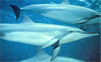
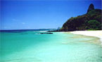 550 kilometres from Recife (a little over an hour by plane), the archipelago of Fernando de Noronha is made up of 21 islands and islets, which rise up from the depths of a sea (4,000 metres deep). The islands are 26 km2 of virtually untouched nature and are under a strict conservation regime. Fernando de Noronha is the main island, full of natural viewing points from which to observe the beauties of the place. It is the only inhabited island and has 16 beaches of dazzling white sand, warm clear waters, shoals of brightly coloured fish and acrobatic dolphins. Natural pools, sea turtles, seaweed and sponges complete the picture. The archipelago is a real paradise for swimmers and divers. The crystal clear waters, in which one can see to a depth of 50 metres, allow the visitor to study 15 of the 18 known species of coral, or simply contemplate the rich marine life.
History of the archipelago
Many controversies surround the discovery of Fernando de Noronha. The map of the area sent in November, 1502 to Ercole d'Este, Duke of Ferrara, shows the archipelago as the "Ilha da Quaresma" (Isle of Lent).. From this it was supposed that knowledge of the existence of the island dated from the expeditions which passed near them during Lent in 1500, 1501, or 1502. The Viscount of Santarem attributed the discovery to Gaspar de Lemos, the captain of the supply ship in Cabral's fleet, sent back to Portugal in 1500 with the news of the discovery of Santa Cruz (Brazil). However, Gaspar's ship did not pass through the area of Fernando de Noronha during Lent; rather, after sailing the coast of Brazil and cutting brazilwood, Gaspar could have sighted the archipelago on June 24, the day of the festival of St. John, whose name he could have given to the island.
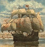 Duarte Leite, after lengthy research, attributed the discovery of the island to the 1501-1502 expedition, whose command mistakenly attributed ownership of the island to Fernao de Loronha. Portuguese historian Jaime Cortesao infers there must have been another expedition to Brazil in 1502-1503, an expedition unknown except for a few clear remains. This would explain the questions as to the mention of the island on maps of the period.
This expedition would have been under the command of Fernao de Loronha, who, by this account, personally began the taming of the land he received as payment for the Brazilwood he brought back from Brazil. It is in the course of this voyage that, according to Duarte Leite, Fernao de Loronha he would have discovered the archipelago named for him.
English, Dutch and French invasions
 In 1534, the Fernando de Noronha Archipelago was invaded by the English, and from 1556 until 1612, it was held by the French. In 1612, Claudio de Abeville, a Capuchin missionary, landed on the island and found one Portuguese and seventeen indian men and women who had been banished from mainland Pernambuco.
In 1628, Noronha was invaded by the Dutch, who were displaced two years later by the expedition commanded by Rui Calaza Borges according to the January 14, 1630 order of Mathias de Albuquerque. In 1635, the Dutch, under the command of Admiral Cornelis Cornelizoon Jol, attacked the island again and occupied it for nineteen years. During this period, the island was used by the Dutch as a site for a treatment and convalescence base for its troops, a third of whom in Pernambuco suffered from diseases such as scurvy and dysentery.
The Island became known as Pavonia, in honor of Michiel de Pauw, one of the directors of the Dutch West Indies Company. In 1646, the Dutchbuilt a small fort on the high ground at the site of the later Forte de Nossa Senhora dos Remedios (Fort of Our Lady of Medicines).
 The Royal Writ of September 7, 1696 ordered the island occupied and garrisoned and the best sites selected for fortification to avoid the constant invasions. However, this order was not obeyed and the Atlantic territory continued at the mercy of invaders.
On September 24, 1700, by order of a Royal Writ, the Capitania of Fernando de Noronha reverted to the Portuguese crown and became part of the Capitania of Pernambuco. Finding it uninhabited and completely abandoned in 1736, the French East Indies Company took the island and renamed it Isle Dauphine.
 In 1737, at the order of Governor Henrique Luis Pereira Freire, 250 police led by Lt. Col. Joao Lobo de Lacerda decisively occupied the island without resistance. To frustrate further attacks by the French, the forts of Nossa Senhora dos Remedios, Nossa Senhora de Conceicao and Santo Antonio were constructed.
First prisioners arrived
The church of N. S. dos Remedios, a landmark of the repopulation of the island, was completed in 1772. About this time, the first prisoners were sent to the island. Initially, prisoners were sent only occasionally, but this development prompted preventive measures which profoundly altered the island environment. Vegetative cover was destroyed and trees were felled to prevent escapes and to eliminate hiding places for inmates; and, non-native species were introduced to the island. Consequences of these changes remain visible today.
In 1897, the government of Pernambuco took control of the penitentiary at Fernando de Noronha and converted it to use as a state prison. It remained under under state control until 1938, when Brazil's federal Ministry of Justice paid CR$ 2,000,000. for it and converted the island to use as a political prison and penal colony.
At the beginning of the 20th century, the English arrived to provide technical cooperation in telegraphy (The South American Company). Later the French came with the French cable and the Italians with Intalcable. In 1942, during World War II, the archipelago was made a Federal Territory, and political and ordinary prisoners were sent to the prison there.
In 1943, a new federal decree called for administration of the archipelago, which had been in the Ministry of War, by a Governor of the Federal Territory of Fernando de Noronha. On August 23, 1943, Col. Tristao de Alencar Araripe became the first governor of the new Federal Territory. The Brazilian army administered Noronha until 1981, by the Brazilian air force until 1986 and by the High Command of the Armed Forces until 1987. Most facilities
on the island, including the airport, roads, schools, and hospital, date from this period of military administration. Agreements between Brazil and the United States allowed for the stationing of Americans on the archipelago from 1942 to 1945 (the Second World War) and from 1957 to 1962 (satellite tracking station operated by the U. S. National Aeronautics and Space Administration).
In 1987, the Federal Territory entered into a period of civilian administration by the Ministry of the Interior. This period, the only civilian administration in the history of the Federal Territory, lasted until 1988, when the new Constitution of Brazil reannexed the archipelago to the State of Pernambuco. Now, it is administered as a State District by a General Administrator appointed by the governor of Pernambuco and approved by its state legislature.
Today, Fernando de Noronha survives on tourism, restricted by the limitations of its delicate ecosystem, and traditional fishing, the catch being returned to the island for local consumption. In addition to the historical interest noted above, the archipelago has been the subject of the attention of various scientists dedicated to the study of its flora, fauna, geology, etc.
Volcanic Islands
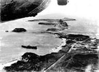
Fernando de Noronha is an isolated group of volcanic islands located in the South Equatorial Atlantic at 03� 51' south and 32� 25' west, approximately 215 miles from Cape Sao Roque in the state of Rio Grande do Norte and 340 miles from Recife, Pernambuco. The main islands are the visible parts of a range of submerged mountains . Consisting of 21 islands, islets and rocks of a volcanic origin, the main island has an area of 7.1 square miles, being 6.2 miles long and 2.2 miles at its maximum width. The perimeter measures 37.2 miles. The base of this enormous volcanic formation is 2480 feet below the surface. The main island, from which the group gets its name, makes up 91% of the total area; the islands of Rata, Sela Gineta, Cabeluda and Sao Jose, together with the islets of Leao and Viuva make up the rest. Geological studies indicate that the islands were formed around 2,000,000 years ago.
Climate
 The climate is tropical, with two well defined seasons: the rainy season from January to August, and the dry season for the rest of the year. The heaviest rains occur between March and July, sometimes reaching almost 8 inches in 24 hours in March and April. October is the dryest month, when rainfall will not be greater than 0.36 inch in a 24 hour period. The average temperature is 77� F, with a variation of only 7.4�. The hottest months are January, February and March. The relative humidity varies little from 81.5 % due to the islands characteristics. Average annual sunshine is 3.215 hours per day, with a maximum in November and a minimum in April.
Land Vegetation
The land vegetation of the islands is made up mostly of vines and bushes with a few species of trees, principally represented by the Nyctaginaceae, Bignoniaceae, Anacardiaceae, Rubiaceae and Euphorbiaceae. There are also a great number of bushes and herbs not native to the island. Most noted among the bushes is the wild bean Capparis cynophallophora and the burra leiteira Sapium scleratum (native), that produces a caustic sap capable of causing serious burns on men and animals. Among the herbs are noted the jitiranas Ipomea spp. and Merremia spp., which are harmful climbing vines. Besides these, some fruit trees have been introduced on the island, such as the papaya, cashew, banana, tamarind, caja, guava, graviola, etc.
Various ornamental species have been introduced also, such as the almond Terminalia catappa, the royal poinciana Tebebuia impectiginosa , caraiba and serratifolia, the jasmin manga Plumeria alba, the eucalyptus, the coconut palm, in small numbers, and the carnauba Copernica prunifera, appear rarely.
Marine Vegetation
Compared to the Brazilian coastline, there is not a great variety of aquatic plants on Fernando de Noronha. This emphasizes the uniqueness of the marine ecosystem of these islands, to which few species have been able to adapt. Perhaps it is due to the lack of nutrients basic to the growth of these algae, since warm currents poor in organic material are characteristic of Fernando de Noronha.
Land Animals
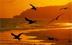 As occurs on other isolated oceanic systems, the land fauna of the Archipelago Fernando de Noronha presents an exuberant bird life, much richer than the vertebrate groups such as amphibians, reptiles, and mammals, which are represented by only a few species.
The archipelago is home to the largest bird breeding colonies of all the islands of the Tropical.
Among the species found here are the viuvinha Anus minutis, which builds it's nest in the trees and on the cliffs of the islands, using algae collected from the surface of the waters; the viuvinha grande anus stolidus; the trinta-reis-de-manto-negro Sterna fuscata; the viuvinha branca Gygis alba, a pure white bird which lays its eggs in the forks of tree branches; the mumbebos Sula dactylatra, the brown mumbebos Sula leucogaster, the red footed mumbebos Sula sula; the catraia Fragata magnificans and the red beak rabo-de-junco Phaethon aethereus (both of these are noted for their extremely long tail feathers).
Inland there are a few land birds, such as the sebito Vireo gracilirostis; the cocoruta Elainia spectabilis and the pomba avoante Zenaida auriculata noronha. As for the reptiles, there are two species of turtles: the aruana or green turtle Chelonia mydas, which uses the islands as its area of reproduction and feeding (herbivorous) and the young individuals of the Eretmochelys imbricata which use the islands for feeding and growth. Likewise, there are two species of lizards: mabuia Mabuya maculata (native) and the teju Tupinambis teguxim, which was introduced to feed on the rats, but prefers other prey such as the eggs and young of birds and turtles.
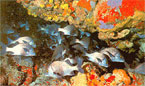
Marine Life
The Archipelago Fernando de Noronha hosts ecologic sites ideal for an exuberant marine animal life, due to its geographic location far from the continent and well within the path of the Southern Equatorial Current, as well as the nature of its clim ate, a fact clearly proven in various experiments.
Tartaruga Eretmochelys imbricata & Mabuya Mabuya maculata
Over the years separate studies have discovered 168 families of mollusks, 72 species of crustaceans, and a large quantity of ornamental fish both native and migratory.
Preservation of the enviroment
 In 1988 approximately 70% of the archipelago was declared a National Marine Park, with the goal of preserving the land and marine environment. It is administered by the IBAMA. Towards its goal research projects are being developed, such as: recording native and migratory bird species both marine and land; studying the behavior and reproduction of the golfinho rotador stenella longirostris; the ecology and reproduction of the crustaceans of the upper, middle and lower coast; shark research and the TAMAR PROJECT (marine turtles). These subjects are offered to the tourists each night at the visitors center of the project, nearby the headquarters of IBAMA.
Today Fernando de Noronha is a model of enviornmental preservation, existing side by side with tourist activities, which are limited by the existing facilities. Permanent works built by the ONG's and Foundations, contribute to the perfecting of the conservational policies.
Introduction
550 kilometres from Recife (a little over an hour by plane), the archipelago of Fernando de Noronha is made up of 21 islands and islets, which rise up from the depths of a sea (4,000 metres deep). The islands are 26 km2 of virtually untouched nature and are under a strict conservation regime. Fernando de Noronha is the main island, full of natural viewing points from which to observe the beauties of the place. It is the only inhabited island and has 16 beaches of dazzling white sand, warm clear waters, shoals of brightly coloured fish and acrobatic dolphins. Natural pools, sea turtles, seaweed and sponges complete the picture. The archipelago is a real paradise for swimmers and divers. The crystal clear waters, in which one can see to a depth of 50 metres, allow the visitor to study 15 of the 18 known species of coral, or simply contemplate the rich marine life. History of the archipelago
Many controversies surround the discovery of Fernando de Noronha. The map of the area sent in November, 1502 to Ercole d'Este, Duke of Ferrara, shows the archipelago as the "Ilha da Quaresma" (Isle of Lent).. From this it was supposed that knowledge of the existence of the island dated from the expeditions which passed near them during Lent in 1500, 1501, or 1502. The Viscount of Santarem attributed the discovery to Gaspar de Lemos, the captain of the supply ship in Cabral's fleet, sent back to Portugal in 1500 with the news of the discovery of Santa Cruz (Brazil). However, Gaspar's ship did not pass through the area of Fernando de Noronha during Lent; rather, after sailing the coast of Brazil and cutting brazilwood, Gaspar could have sighted the archipelago on June 24, the day of the festival of St. John, whose name he could have given to the island.
Duarte Leite, after lengthy research, attributed the discovery of the island to the 1501-1502 expedition, whose command mistakenly attributed ownership of the island to Fernao de Loronha. Portuguese historian Jaime Cortesao infers there must have been another expedition to Brazil in 1502-1503, an expedition unknown except for a few clear remains. This would explain the questions as to the mention of the island on maps of the period. This expedition would have been under the command of Fernao de Loronha, who, by this account, personally began the taming of the land he received as payment for the Brazilwood he brought back from Brazil. It is in the course of this voyage that, according to Duarte Leite, Fernao de Loronha he would have discovered the archipelago named for him.
English, Dutch and French invasions
In 1534, the Fernando de Noronha Archipelago was invaded by the English, and from 1556 until 1612, it was held by the French. In 1612, Claudio de Abeville, a Capuchin missionary, landed on the island and found one Portuguese and seventeen indian men and women who had been banished from mainland Pernambuco.In 1628, Noronha was invaded by the Dutch, who were displaced two years later by the expedition commanded by Rui Calaza Borges according to the January 14, 1630 order of Mathias de Albuquerque. In 1635, the Dutch, under the command of Admiral Cornelis Cornelizoon Jol, attacked the island again and occupied it for nineteen years. During this period, the island was used by the Dutch as a site for a treatment and convalescence base for its troops, a third of whom in Pernambuco suffered from diseases such as scurvy and dysentery.
The Island became known as Pavonia, in honor of Michiel de Pauw, one of the directors of the Dutch West Indies Company. In 1646, the Dutchbuilt a small fort on the high ground at the site of the later Forte de Nossa Senhora dos Remedios (Fort of Our Lady of Medicines).
The Royal Writ of September 7, 1696 ordered the island occupied and garrisoned and the best sites selected for fortification to avoid the constant invasions. However, this order was not obeyed and the Atlantic territory continued at the mercy of invaders.On September 24, 1700, by order of a Royal Writ, the Capitania of Fernando de Noronha reverted to the Portuguese crown and became part of the Capitania of Pernambuco. Finding it uninhabited and completely abandoned in 1736, the French East Indies Company took the island and renamed it Isle Dauphine.
In 1737, at the order of Governor Henrique Luis Pereira Freire, 250 police led by Lt. Col. Joao Lobo de Lacerda decisively occupied the island without resistance. To frustrate further attacks by the French, the forts of Nossa Senhora dos Remedios, Nossa Senhora de Conceicao and Santo Antonio were constructed.First prisioners arrived
The church of N. S. dos Remedios, a landmark of the repopulation of the island, was completed in 1772. About this time, the first prisoners were sent to the island. Initially, prisoners were sent only occasionally, but this development prompted preventive measures which profoundly altered the island environment. Vegetative cover was destroyed and trees were felled to prevent escapes and to eliminate hiding places for inmates; and, non-native species were introduced to the island. Consequences of these changes remain visible today.
In 1897, the government of Pernambuco took control of the penitentiary at Fernando de Noronha and converted it to use as a state prison. It remained under under state control until 1938, when Brazil's federal Ministry of Justice paid CR$ 2,000,000. for it and converted the island to use as a political prison and penal colony.
At the beginning of the 20th century, the English arrived to provide technical cooperation in telegraphy (The South American Company). Later the French came with the French cable and the Italians with Intalcable. In 1942, during World War II, the archipelago was made a Federal Territory, and political and ordinary prisoners were sent to the prison there.
In 1943, a new federal decree called for administration of the archipelago, which had been in the Ministry of War, by a Governor of the Federal Territory of Fernando de Noronha. On August 23, 1943, Col. Tristao de Alencar Araripe became the first governor of the new Federal Territory. The Brazilian army administered Noronha until 1981, by the Brazilian air force until 1986 and by the High Command of the Armed Forces until 1987. Most facilities
on the island, including the airport, roads, schools, and hospital, date from this period of military administration. Agreements between Brazil and the United States allowed for the stationing of Americans on the archipelago from 1942 to 1945 (the Second World War) and from 1957 to 1962 (satellite tracking station operated by the U. S. National Aeronautics and Space Administration).
In 1987, the Federal Territory entered into a period of civilian administration by the Ministry of the Interior. This period, the only civilian administration in the history of the Federal Territory, lasted until 1988, when the new Constitution of Brazil reannexed the archipelago to the State of Pernambuco. Now, it is administered as a State District by a General Administrator appointed by the governor of Pernambuco and approved by its state legislature.
Today, Fernando de Noronha survives on tourism, restricted by the limitations of its delicate ecosystem, and traditional fishing, the catch being returned to the island for local consumption. In addition to the historical interest noted above, the archipelago has been the subject of the attention of various scientists dedicated to the study of its flora, fauna, geology, etc.
Volcanic Islands
Fernando de Noronha is an isolated group of volcanic islands located in the South Equatorial Atlantic at 03� 51' south and 32� 25' west, approximately 215 miles from Cape Sao Roque in the state of Rio Grande do Norte and 340 miles from Recife, Pernambuco. The main islands are the visible parts of a range of submerged mountains . Consisting of 21 islands, islets and rocks of a volcanic origin, the main island has an area of 7.1 square miles, being 6.2 miles long and 2.2 miles at its maximum width. The perimeter measures 37.2 miles. The base of this enormous volcanic formation is 2480 feet below the surface. The main island, from which the group gets its name, makes up 91% of the total area; the islands of Rata, Sela Gineta, Cabeluda and Sao Jose, together with the islets of Leao and Viuva make up the rest. Geological studies indicate that the islands were formed around 2,000,000 years ago.
Climate
The climate is tropical, with two well defined seasons: the rainy season from January to August, and the dry season for the rest of the year. The heaviest rains occur between March and July, sometimes reaching almost 8 inches in 24 hours in March and April. October is the dryest month, when rainfall will not be greater than 0.36 inch in a 24 hour period. The average temperature is 77� F, with a variation of only 7.4�. The hottest months are January, February and March. The relative humidity varies little from 81.5 % due to the islands characteristics. Average annual sunshine is 3.215 hours per day, with a maximum in November and a minimum in April.Land Vegetation
The land vegetation of the islands is made up mostly of vines and bushes with a few species of trees, principally represented by the Nyctaginaceae, Bignoniaceae, Anacardiaceae, Rubiaceae and Euphorbiaceae. There are also a great number of bushes and herbs not native to the island. Most noted among the bushes is the wild bean Capparis cynophallophora and the burra leiteira Sapium scleratum (native), that produces a caustic sap capable of causing serious burns on men and animals. Among the herbs are noted the jitiranas Ipomea spp. and Merremia spp., which are harmful climbing vines. Besides these, some fruit trees have been introduced on the island, such as the papaya, cashew, banana, tamarind, caja, guava, graviola, etc.
Various ornamental species have been introduced also, such as the almond Terminalia catappa, the royal poinciana Tebebuia impectiginosa , caraiba and serratifolia, the jasmin manga Plumeria alba, the eucalyptus, the coconut palm, in small numbers, and the carnauba Copernica prunifera, appear rarely.
Marine Vegetation
Compared to the Brazilian coastline, there is not a great variety of aquatic plants on Fernando de Noronha. This emphasizes the uniqueness of the marine ecosystem of these islands, to which few species have been able to adapt. Perhaps it is due to the lack of nutrients basic to the growth of these algae, since warm currents poor in organic material are characteristic of Fernando de Noronha.
Land Animals
As occurs on other isolated oceanic systems, the land fauna of the Archipelago Fernando de Noronha presents an exuberant bird life, much richer than the vertebrate groups such as amphibians, reptiles, and mammals, which are represented by only a few species.The archipelago is home to the largest bird breeding colonies of all the islands of the Tropical.
Among the species found here are the viuvinha Anus minutis, which builds it's nest in the trees and on the cliffs of the islands, using algae collected from the surface of the waters; the viuvinha grande anus stolidus; the trinta-reis-de-manto-negro Sterna fuscata; the viuvinha branca Gygis alba, a pure white bird which lays its eggs in the forks of tree branches; the mumbebos Sula dactylatra, the brown mumbebos Sula leucogaster, the red footed mumbebos Sula sula; the catraia Fragata magnificans and the red beak rabo-de-junco Phaethon aethereus (both of these are noted for their extremely long tail feathers).
Inland there are a few land birds, such as the sebito Vireo gracilirostis; the cocoruta Elainia spectabilis and the pomba avoante Zenaida auriculata noronha. As for the reptiles, there are two species of turtles: the aruana or green turtle Chelonia mydas, which uses the islands as its area of reproduction and feeding (herbivorous) and the young individuals of the Eretmochelys imbricata which use the islands for feeding and growth. Likewise, there are two species of lizards: mabuia Mabuya maculata (native) and the teju Tupinambis teguxim, which was introduced to feed on the rats, but prefers other prey such as the eggs and young of birds and turtles.
Marine Life
The Archipelago Fernando de Noronha hosts ecologic sites ideal for an exuberant marine animal life, due to its geographic location far from the continent and well within the path of the Southern Equatorial Current, as well as the nature of its clim ate, a fact clearly proven in various experiments.
Tartaruga Eretmochelys imbricata & Mabuya Mabuya maculata
Over the years separate studies have discovered 168 families of mollusks, 72 species of crustaceans, and a large quantity of ornamental fish both native and migratory.
Preservation of the enviroment
In 1988 approximately 70% of the archipelago was declared a National Marine Park, with the goal of preserving the land and marine environment. It is administered by the IBAMA. Towards its goal research projects are being developed, such as: recording native and migratory bird species both marine and land; studying the behavior and reproduction of the golfinho rotador stenella longirostris; the ecology and reproduction of the crustaceans of the upper, middle and lower coast; shark research and the TAMAR PROJECT (marine turtles). These subjects are offered to the tourists each night at the visitors center of the project, nearby the headquarters of IBAMA.Today Fernando de Noronha is a model of enviornmental preservation, existing side by side with tourist activities, which are limited by the existing facilities. Permanent works built by the ONG's and Foundations, contribute to the perfecting of the conservational policies.